

Share This:

Annapurna Circuit Trek Map: A Complete Guide by Mountain Treks Nepal
Annapurna Circuit Trek is a journey through one of the most picturesque landscapes on the planet. This circumnavigating route of Mount Annapurna (8,091m) takes you across charming villages, lush woodlands, cascading rivers and streams with breathtaking views of the Himalayan peaks on the backdrop. Annapurna Circuit Trek map which features an intricate network of trails in the region, side routes, hidden gems, major highlights, villages and aid posts makes the navigation in this exciting route smooth and efficient.
With a trekking distance that stretches from 160 to 230 km (100 to 145 miles), this trail presents dramatic altitude shifts, steep rugged climbs, and diverse climatic zones from subtropical forest to the arid terrain of Thorong La Pass (5,416m).
Having a map of the Annapurna Circuit is not just about orientation it’s about smart planning, safety, and uncovering the best the region has to offer. With Mountain Treks Nepal’s 9-day itinerary, you’ll explore the most iconic highlights efficiently and comfortably.
Key Sections of Annapurna Circuit Trek Map with Elevation Details
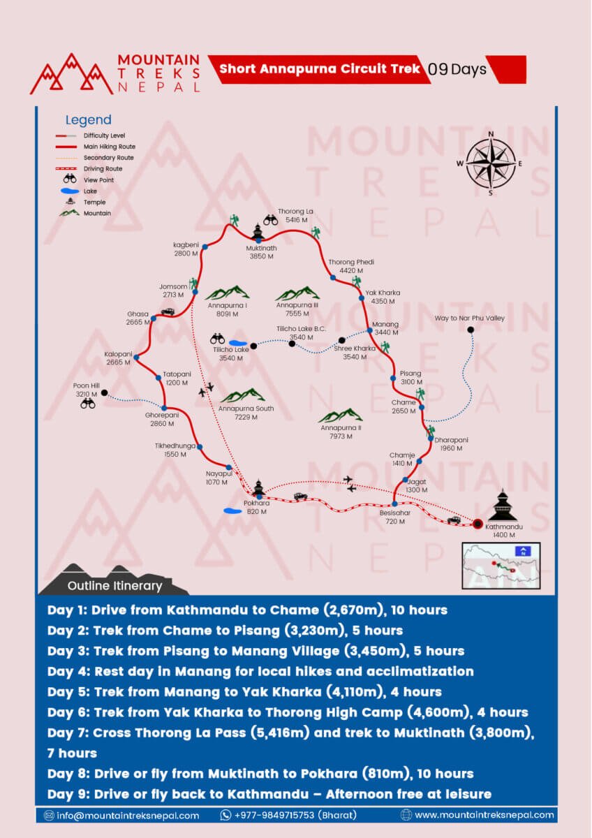
Day 1: Drive from Kathmandu to Chame (2,670m)
- Drive Duration: 10 hours
- Highlights: Riverside views, terraced fields, and the first views of the Annapurna range.
Day 2: Trek from Chame to Pisang (3,230m)
- Trek Duration: 5 hours
- Highlights: Views of Lamjung Himal, pine forests, Tibetan-style villages.
Day 3: Trek from Pisang to Manang (3,450m)
- Trek Duration: 5 hours
- Highlights: Gangapurna Glacier, Annapurna III, Tibetan architecture.
Day 4: Acclimatization Day in Manang
- Activities: Hike to Gangapurna Lake, Ice Lake, or visit monasteries.
- Purpose: Altitude acclimatization before ascending higher.
Day 5: Trek from Manang to Yak Kharka (4,110m)
- Trek Duration: 4 hours
- Highlights: Alpine landscapes, yak pastures, peaceful terrain.
Day 6: Trek from Yak Kharka to Thorong High Camp (4,600m)
- Trek Duration: 4 hours
- Highlights: Mountain ridges, views of Chulu peaks.
Day 7: Cross Thorong La Pass (5,416m) and trek to Muktinath (3,800m)
- Trek Duration: 7 hours
- Highlights: One of the highest trekking passes in the world, panoramic views, sacred Muktinath Temple.
Day 8: Drive or fly from Muktinath to Pokhara (820m)
- Drive Duration: 10 hours (or flight from Jomsom)
- Highlights: Scenic drive through the Kali Gandaki Gorge.
Day 9: Drive or fly back to Kathmandu (1,400m)
- Highlights: Leisure time for city exploration or rest.
Why Use a Map for the Annapurna Circuit Trek?
Navigation and Route Guidance
A map keeps you on the correct trail, helps locate alternate paths, and provides a visual reference of terrain and elevation.
Safety and Risk Mitigation
The circuit includes narrow trails, potential landslide zones, and high passes. A good map highlights these areas so you can stay alert and plan accordingly.
Time Management
An elevation map helps calculate trekking durations, set rest stops, and avoid fatigue.
Locating Key Resources
Maps show villages, teahouses, water stations, and aid points critical for supplies and safety.
Emergency Planning
Identify clinics, helipads, and exit points for emergencies, especially near Thorong La.
Best Time to Trek the Annapurna Circuit
- Autumn (Sept–Nov): Best views and stable weather.
- Spring (Mar–May): Wildflowers, mild temperatures.
Avoid monsoon (June–Aug) due to landslides and winter (Dec–Feb) when snow can block Thorong La.
Understanding the Map: Key Points
Elevation Highlights
- Kathmandu: 1,400m
- Chame: 2,670m
- Pisang: 3,230m
- Manang: 3,450m
- Yak Kharka: 4,110m
- Thorong High Camp: 4,600m
- Thorong La Pass: 5,416m
- Muktinath: 3,800m
- Pokhara: 820m
Key Villages and Landmarks
- Manang: Culture, rest, and acclimatization
- Muktinath: Spiritual pilgrimage site
- Jomsom: Gateway to Lower Mustang
Trail Features
- Main hiking trail marked in red
- Lakes: Tilicho Lake nearby
- Temples, viewpoints, and driving routes clearly marked
Tips for Using Annapurna Circuit Trek Map Efficiently
- Understand Topographic Lines
They show elevation gain/loss. Closely spaced lines = steep areas.
- Learn the Symbols
Identify teahouses, bridges, view points, temples, and passes.
- Cross-Reference Digital and Physical Maps
Carry both. GPS can fail in high-altitude or cold conditions.
- Don’t Misjudge Distances
Use maps that include time estimates and elevation charts.
- Mark Emergency Points
Know where the medical centers, evacuation routes, and helipads are.
Where to Get the Annapurna Circuit Map?
- In Kathmandu: Trekking shops in Thamel
- In Pokhara: Lakeside bookstores and gear stores
- Online: Downloadable maps (e.g., Maps.me, Gaia GPS)
Mountain Treks Nepal provides a detailed map and full guidebook when you book with us.
Other Itinerary Options
Annapurna Circuit Trek – 12 Days
For a more immersive experience including more villages.
Annapurna Circuit Trek – 10 Days
Ideal for those with limited time; includes drive options.
Why Choose Mountain Treks Nepal?
We are locally rooted and globally trusted. Our seasoned guides, carefully crafted itineraries, and commitment to your safety set us apart.
Our Services:
- Government-licensed guides
- 24/7 on-ground support
- Small group and custom treks
- Eco-conscious and ethical practices
- Excellent value and reviews
📧 info@mountaintreksnepal.com
📞 +977-9849715753 (Bharat)
🌐 www.mountaintreksnepal.com
Final Thoughts
The Annapurna Circuit Trek Map is more than just a navigation tool it’s your roadmap to adventure, safety, and unforgettable Himalayan beauty. Whether you choose our 9-day efficient route or extend it for deeper exploration, Mountain Treks Nepal ensures your journey is meaningful, safe, and unforgettable.
Start planning today and let the Himalayas change your life.